Property Record
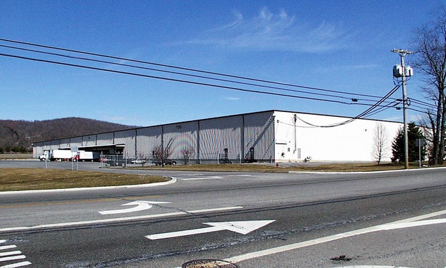
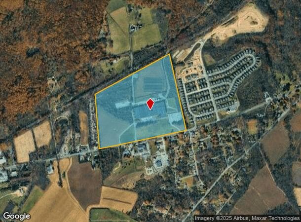
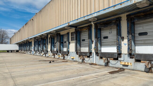
555 State Route 57, Port Murray, NJ 07865

This Property Is For Sale
NEARBY LISTINGS FOR SALE OR LEASE
Property Detail
555 State Route 57
16-01501-0000-00007-0000-S01
Warren
Industrialgeneral
New Jersey
X
7
34041C0239E
3.32 AC
2024
Warren
2025
Northern New Jersey
031500
Allentown-Bethlehem-Easton, PA-NJ
DEMOGRAPHICS near 555 State Route 57
1 Mile
3 Mile
5 Mile
2024 Total Population
687
11,124
27,575
2029 Population
725
11,299
27,998
Pop Growth 2024-2029
+ 5.53%
+ 1.57%
+ 1.53%
Average Age
45
43
43
2024 Total Households
261
4,327
10,752
HH Growth 2024-2029
+ 5.75%
+ 1.55%
+ 1.53%
Median Household Inc
$73,076
$85,672
$94,284
Avg Household Size
2.60
2.50
2.50
2024 Avg HH Vehicles
2.00
2.00
2.00
Median Home Value
$286,708
$301,967
$318,027
Median Year Built
1965
1965
1970
Nearby Places
- Restaurants
- Banks
- Shops
- Fitness
- Groceries
PUBLIC TRANSPORTATION
COMMUTER RAIL
Hackettstown (Montclair-Boonton Line - NJ Transit Commuter Rail (NJ Transit), Morris & Essex Morristown Line - NJ Transit Commuter Rail (NJ Transit))
DRIVE
WALK
Distance
Hackettstown (Montclair-Boonton Line - NJ Transit Commuter Rail (NJ Transit), Morris & Essex Morristown Line - NJ Transit Commuter Rail (NJ Transit))
20 min
9.8 mi
AIRPORT
Lehigh Valley International
DRIVE
WALK
Distance
Lehigh Valley International
53 min
30.5 mi
Trenton Mercer
DRIVE
WALK
Distance
Trenton Mercer
64 min
43.1 mi
Freight Ports
Maher Terminal
DRIVE
WALK
Distance
Maher Terminal
73 min
56.5 mi
Nearby Properties
Address
Land Use
TOTAL SIZE
Lot Size
Zoning
Address
Land Use
TOTAL SIZE
Lot Size
Zoning
Address
Land Use
TOTAL SIZE
Lot Size
Zoning
46.85 AC
R-40
Address
Land Use
TOTAL SIZE
Lot Size
Zoning
Address
Land Use
TOTAL SIZE
Lot Size
Zoning
32.90 AC
PL
Address
Land Use
TOTAL SIZE
Lot Size
Zoning
226,375 SF
50.41 AC
Address
Land Use
TOTAL SIZE
Lot Size
Zoning
73,058 SF
19.68 AC
Address
Land Use
TOTAL SIZE
Lot Size
Zoning
26,281 SF
105 AC
RC
Address
Land Use
TOTAL SIZE
Lot Size
Zoning
Address
Land Use
TOTAL SIZE
Lot Size
Zoning
Address
Land Use
TOTAL SIZE
Lot Size
Zoning
15.80 AC
I
Address
Land Use
TOTAL SIZE
Lot Size
Zoning
1,280 SF
240.85 AC
PVD
Address
Land Use
TOTAL SIZE
Lot Size
Zoning
1.87 AC
PVD
Address
Land Use
TOTAL SIZE
Lot Size
Zoning
4.89 AC
R4
Address
Land Use
TOTAL SIZE
Lot Size
Zoning
12,448 SF
2 AC
RC
Address
Land Use
TOTAL SIZE
Lot Size
Zoning
1,520 SF
302.94 AC
RC
Address
Land Use
TOTAL SIZE
Lot Size
Zoning
38,415 SF
4 AC
Address
Land Use
TOTAL SIZE
Lot Size
Zoning
2,010 SF
1.68 AC
B1
Address
Land Use
TOTAL SIZE
Lot Size
Zoning
5.52 AC
R4
Address
Land Use
TOTAL SIZE
Lot Size
Zoning
10,698 SF
2.35 AC
B1
Address
Land Use
TOTAL SIZE
Lot Size
Zoning
1,597.03 AC
Address
Land Use
TOTAL SIZE
Lot Size
Zoning
1,738 SF
25 AC
MR
Address
Land Use
TOTAL SIZE
Lot Size
Zoning
4,370 SF
35.50 AC
Address
Land Use
TOTAL SIZE
Lot Size
Zoning
76 AC
PI
Address
Land Use
TOTAL SIZE
Lot Size
Zoning
1,900 SF
0.01 AC
B2
Address
Land Use
TOTAL SIZE
Lot Size
Zoning
4,704 SF
1.16 AC
B2
Address
Land Use
TOTAL SIZE
Lot Size
Zoning
5,064 SF
129.92 AC
Address
Land Use
TOTAL SIZE
Lot Size
Zoning
9,262 SF
0.86 AC
R3
Address
Land Use
TOTAL SIZE
Lot Size
Zoning
1,370 SF
0.01 AC
B2
Address
Land Use
TOTAL SIZE
Lot Size
Zoning
4,163 SF
2.59 AC
HC
Address
Land Use
TOTAL SIZE
Lot Size
Zoning
7,200 SF
1 AC
PL
The World's #1 Commercial Real Estate Marketplace
Connect with us
© 2025 CoStar Group
The information above has been obtained from sources believed reliable. While we do not doubt its accuracy we have not verified it and make no guarantee, warranty or representation about it. It is your responsibility to independently confirm its accuracy and completeness. Any projections, opinions, assumptions, or estimates used are for example only and do not represent the current or future performance of the property. The value of this transaction to you depends on tax and other factors which should be evaluated by your tax, financial, and legal advisors. You and your advisors should conduct a careful, independent investigation of the property to determine to your satisfaction the suitability of the property for your needs.